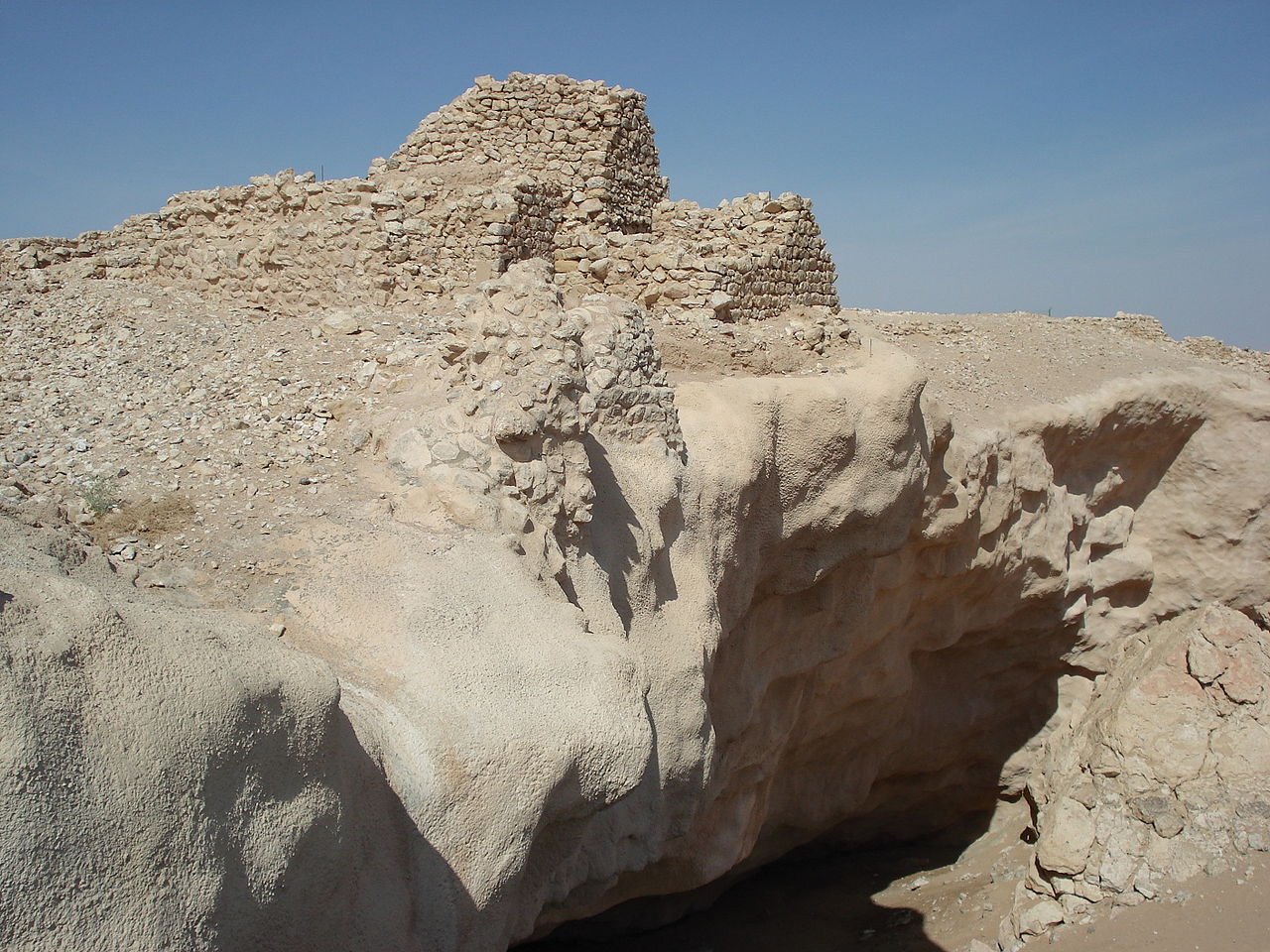
Shisr, the Ubar Site
On February 5, 1992, a filmmaker and a NASA scientist announced they had found the Atlantis of the Sands using satellite radar. The archaeologist who ran the dig spent the next few years explaining that they had not. The fort and the sinkhole that swallowed it are still there.
Search Area
loading map…
- Start point
- Salalah
- Visitor access
- Archaeological site of Shisr, Shisr village, Dhofar Governorate
- Measured from
- The fort enclosure
- Drive
- 2 to 3 hours each way
- Road
- Sealed highway throughout
- Nearest town
- Shisr
The zone drawn here covers the waterhole and the ground around it where the buried caravan tracks converge. It is a general search zone and not an exact site.
The Legend
Ubar is the caravan city of the frankincense trade, named in Arab tradition as the city of 'Ad, destroyed for its arrogance and buried in sand. T. E. Lawrence called it the Atlantis of the Sands and never went looking. Others did, for most of the 20th century.
On February 5, 1992, at a press conference at the Huntington Library in California, the filmmaker Nicholas Clapp and the JPL scientist Ronald Blom announced they had found it. They had used Landsat data and space shuttle radar to trace old caravan tracks under the sand, and the tracks converged on a waterhole at Shisr. The New York Times, UPI, and the Baltimore Sun all ran it.
What the excavation found
An octagonal fort with towers, standing over a limestone cavern. At some point the roof of the cavern gave way and most of the fort dropped into the hole. There was a well, and pottery indicating long-distance trade, and it had clearly been an important stop.
Juris Zarins, the archaeologist who led the dig on the ground, began walking the claim back almost immediately. In a 1996 interview he said that Ubar in the classical and Arab sources "refers to a region and a group of people, not to a specific town," and that Shisr was a significant site but not the lost city. Clapp himself later qualified the identification. The press conference had gone out ahead of the archaeology.
What is left
The story is a good one about how a discovery gets announced. Satellite imagery did find something real. The something real was a caravan fort, which is a serious archaeological result, and it was sold as a legend confirmed.
Shisr is now one of four components of the Land of Frankincense, inscribed by UNESCO in 2000. The fort, the collapsed sinkhole, and the cleared well are all visible.
What May Be Out There
The thing being looked for here is a city rather than a hoard, and the argument is over whether the ruin in the sand is it.
- Ubar, the caravan city named in Arab tradition, associated with the people of 'Ad.
- The frankincense wealth that moved through the desert watering stations on the road north.
- Whatever the rest of the fort held before the cavern roof gave way underneath it.
- Recovered so far: an octagonal fort with towers, a well, and pottery from long-distance trade. No inscription naming the place.
The Evidence
Documented record
- The fort at Shisr, excavated from 1992, with towers and a walled enclosure standing over a collapsed limestone cavern.
- Landsat and space shuttle radar imagery showing buried caravan tracks converging on the waterhole.
- Trade pottery establishing the site's place on the frankincense road.
- The UNESCO inscription of the Land of Frankincense in 2000, which lists Shisr as one of its four components.
Legend and hearsay
- The identification of Shisr as Ubar, announced at a press conference on February 5, 1992, and walked back by the excavation's own director within a few years.
- 'Ad as a single destroyed city, rather than a region and a people, which is how Juris Zarins read the sources.
- The Atlantis of the Sands, a phrase T. E. Lawrence applied to a place he never went to look for.
Known Clues
The press conference. The filmmaker Nicholas Clapp and the JPL scientist Ronald Blom announced the find at the Huntington Library in California in February 1992, and the wire services carried it the same day. The announcement came out ahead of the archaeology, which is the whole problem with this site's reputation and not a small detail in it.
Zarins's retraction. The archaeologist who ran the dig on the ground began qualifying the claim almost immediately. He said the sources use Ubar for a region and a people rather than a town, and that Shisr was an important station on the incense road but not the lost city. Clapp later qualified it too. The correction never traveled as far as the announcement did.
The sinkhole. The fort is standing on a limestone cavern that collapsed, taking most of the structure down with it. That is the detail that makes the site legible on the ground: you can see the fort and the hole that swallowed it in the same view, which is the closest thing here to a city destroyed for its arrogance.
Visiting Information
Free, open air, and unstaffed, best visited in daylight. The site is fenced with marked buffer zones and the old well has been cleared of debris.
The drive from Salalah takes 2 to 3 hours each way on sealed highway, so this is a full day rather than a detour. There is nothing at the site itself: no cafe, no shade, no fuel for a long way in either direction. Carry water.
November through March is the season. The khareef monsoon that turns Salalah green from June to September does not reach the interior, which stays extremely hot. Finds from the excavation are displayed at the Museum of the Frankincense Land in Salalah, which is the better place to see the objects. Oman carried a US advisory of Level 3 as of 2026.
Reality Check
Something real was found here, and it was oversold. Satellite imagery did trace buried caravan tracks to a waterhole, and digging at that waterhole did produce a substantial fortified station on the frankincense road, which is a serious result. It was announced instead as the confirmation of a legend. The man who directed the excavation spent the following years explaining that the sources describe a region and a people rather than a town, and that nothing recovered names the site. What stands in the sand is a caravan fort that fell into a sinkhole. Ubar remains a story about a place, and this is a place without the story attached.
Field Gallery
No approved field photos yet. You could be first.
Community Notes
No community notes yet.
Explore More Mysteries

Isabella Stewart Gardner Museum Theft
Two men in police uniforms spent 81 minutes inside the Isabella Stewart Gardner Museum on March 18, 1990, and left with 13 works the FBI valued at more than $500 million. None has been recovered and no one has been charged. The museum repaired the frames the thieves left behind and put them back on the walls as placeholders.

Laguna de Guatavita
El Dorado was a man, not a city. The Muisca covered a new ruler in gold dust and floated him out onto this lake to throw offerings into it. In the 1580s, a merchant cut a notch into the crater rim to drain it, and the notch is still there.

Lake Toplitz
In the summer of 1959 divers working for the German magazine Stern pulled 15 crates out of a mountain lake in Styria. Fourteen of them held counterfeit British banknotes, printed by the SS under Operation Bernhard to wreck confidence in the pound. Farmers had watched uniformed men carry crates down to the shore in 1945, and the question of what else went into the water has never closed.

Ali Pasha's Treasure
Ali Pasha ruled Epirus from Ioannina from 1788 and was killed on February 5, 1822, in a monastery on the island in Lake Pamvotida, where he had taken refuge from the Sultan's troops. The fortune he was said to have hidden before his fall has been searched for ever since. Searchers have dug for it around Ioannina and as far away as Thessaly, and found nothing.